
File:Wfm rathlin.jpg

預覽大小:800 × 593 像素。 其他解析度:320 × 237 像素 | 640 × 474 像素 | 1,024 × 758 像素 | 1,280 × 948 像素。
原始檔案 (1,280 × 948 像素,檔案大小:216 KB,MIME 類型:image/jpeg)
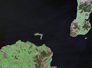
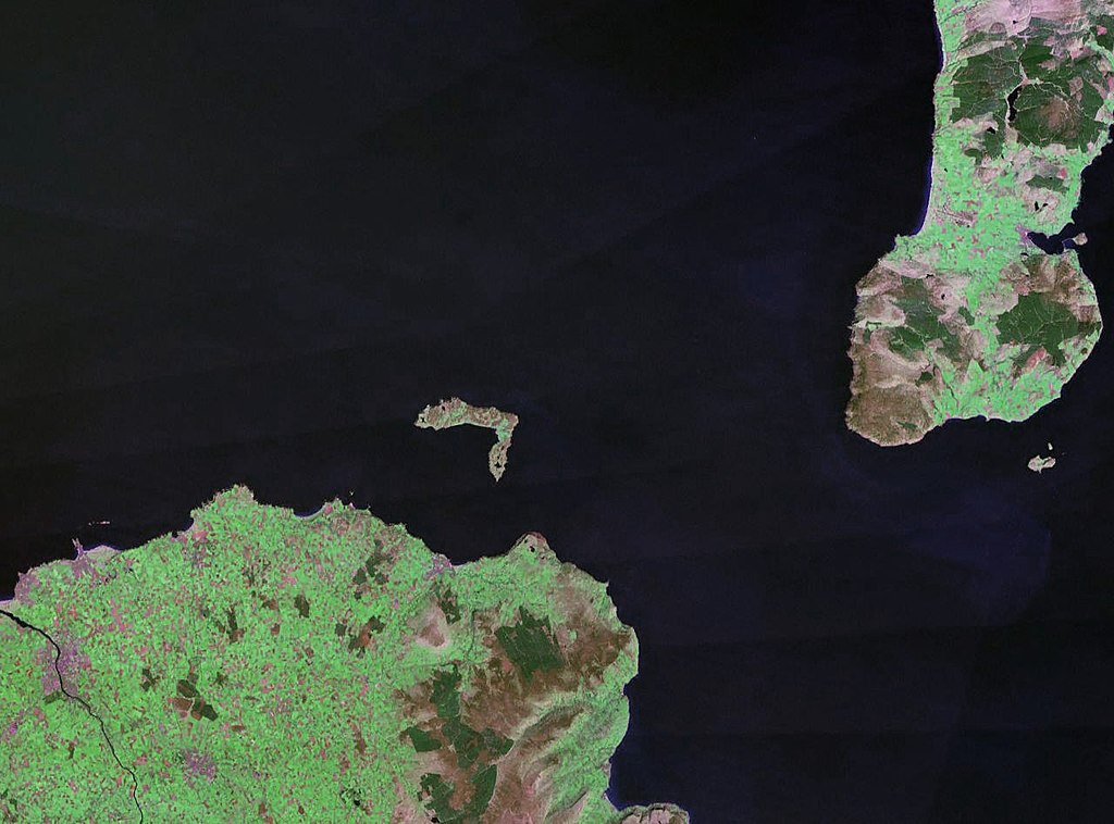
| 描述 | Rathlin Island in Northern Ireland. The coast of County Antrim is to the south, and the tip of the Kintyre Peninsula is to the east. |
| 日期 | 約1990年 |
| 來源 |
NASA World Wind (landsat geocover 1990 data) Original image obtained fron NASA World Wind, colour and saturation tweaked with Adobe Photoshop. |
| 作者 | NASA |
| 授權許可 (重用此檔案) |
USgov-PD |
| 本圖像屬於公有領域,因其為NASA的World Wind衛星地圖瀏覽器的一張截圖,且使用了公有領域圖層,如Blue Marble、MODIS、Landsat、SRTM、USGS、GLOBE等。
|
 |
檔案歷史
點選日期/時間以檢視該時間的檔案版本。
| 日期/時間 | 縮圖 | 尺寸 | 使用者 | 備註 | |
|---|---|---|---|---|---|
| 目前 | 2006年4月24日 (一) 22:30 | | 1,280 × 948(216 KB) | Finlay McWalter | {{Information| |Description=Rathlin Island |Source=NASA World Wind (landsat geocover 1990 data) |Date=c. 1990 |Author=NASA |Permission={{PD-WorldWind}} |other_versions= }} |
檔案用途
下列頁面有用到此檔案:
全域檔案使用狀況
以下其他 wiki 使用了這個檔案:
- af.wikipedia.org 的使用狀況
- br.wikipedia.org 的使用狀況
- ca.wikipedia.org 的使用狀況
- ceb.wikipedia.org 的使用狀況
- cs.wikipedia.org 的使用狀況
- da.wikipedia.org 的使用狀況
- de.wikipedia.org 的使用狀況
- en.wikipedia.org 的使用狀況
- eo.wikipedia.org 的使用狀況
- es.wikipedia.org 的使用狀況
- et.wikipedia.org 的使用狀況
- eu.wikipedia.org 的使用狀況
- fr.wikipedia.org 的使用狀況
- ga.wikipedia.org 的使用狀況
- gv.wikipedia.org 的使用狀況
- hu.wikipedia.org 的使用狀況
- ja.wikipedia.org 的使用狀況
- kk.wikipedia.org 的使用狀況
- lt.wikipedia.org 的使用狀況
- nn.wikipedia.org 的使用狀況
- no.wikipedia.org 的使用狀況
- pl.wikipedia.org 的使用狀況
- pt.wikipedia.org 的使用狀況
- ru.wikipedia.org 的使用狀況
- sv.wikipedia.org 的使用狀況
- www.wikidata.org 的使用狀況