跳至內容

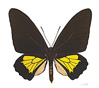
File:Troides oblogomaculatus papuensis MHNT dos.jpg

頁面內容不支援其他語言。
這個檔案來自維基共享資源
維基百科,自由的百科全書

原始檔案 (4,980 × 4,032 像素,檔案大小:7.57 MB,MIME 類型:image/jpeg


摘要

Troides oblongomaculatus papuensis (Wallace, 1865)

This is one of the images forming part of the Valued image set: Troides oblongomaculatus (Oblong-spotted Birdwing) Imago on Wikimedia Commons. The image set has been assessed under the valued image set criteria and is considered the most valued set on Commons within the scope:
Troides oblongomaculatus (Oblong-spotted Birdwing) Imago

You can see its nomination at Commons:Valued image candidates/Troides oblogomaculatus.

描述
Deutsch: - Dorsalansicht
Fundort: Manki Range, Bulolo, Morobe Province, Papua-Neuguinea
English: - Dorsal side
Locality: Manki Range, Bulolo, Morobe Province Papua New Guinea
Français : - Face dorsale
Localité: Manki Range, Bulolo, Province de Monrobe, Papouasie-Nouvelle-Guinée
institution QS:P195,Q422
日期
來源 自己的作品
作者 Didier Descouens
授權許可
(重用此檔案)
我,本作品的著作權持有者,決定用以下授權條款發佈本作品:
w:zh:創用CC
姓名標示 相同方式分享
您可以自由:
  • 分享 – 複製、發佈和傳播本作品
  • 重新修改 – 創作演繹作品
惟需遵照下列條件:
  • 姓名標示 – 您必須指名出正確的製作者,和提供授權條款的連結,以及表示是否有對內容上做出變更。您可以用任何合理的方式來行動,但不得以任何方式表明授權條款是對您許可或是由您所使用。
  • 相同方式分享 – 如果您利用本素材進行再混合、轉換或創作,您必須基於如同原先的相同或兼容的條款,來分布您的貢獻成品。
其他版本
拍攝地點43° 35′ 38.03″ 北, 1° 26′ 57.23″ 東 Kartographer map based on OpenStreetMap.位於此地的本圖片與其他圖片: OpenStreetMapinfo

說明

添加單行說明來描述出檔案所代表的內容

在此檔案描寫的項目

描繪內容

視角坐標 繁體中文 (已轉換拼寫)

43°35'38.02980593962"N, 1°26'57.22698211670"E

攝影器材 繁體中文 (已轉換拼寫)

索尼ALPHA DSLR-A850 繁體中文 (已轉換拼寫)

檔案歷史

點選日期/時間以檢視該時間的檔案版本。

日期/時間縮⁠圖尺寸使用者備⁠註
目前2011年8月22日 (一) 16:47於 2011年8月22日 (一) 16:47 版本的縮圖4,980 × 4,032(7.57 MB)Archaeodontosaurus{{Information |Description ={{en|1=x}} |Source ={{own}} |Author =Archaeodontosaurus |Date = |Permission = |other_versions = }}

下列頁面有用到此檔案:

全域檔案使用狀況

以下其他 wiki 使用了這個檔案:

詮釋資料