
File:Wfm rathlin.jpg

本预览的尺寸:800 × 593像素。 其他分辨率:320 × 237像素 | 640 × 474像素 | 1,024 × 758像素 | 1,280 × 948像素。
原始文件 (1,280 × 948像素,文件大小:216 KB,MIME类型:image/jpeg)
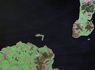
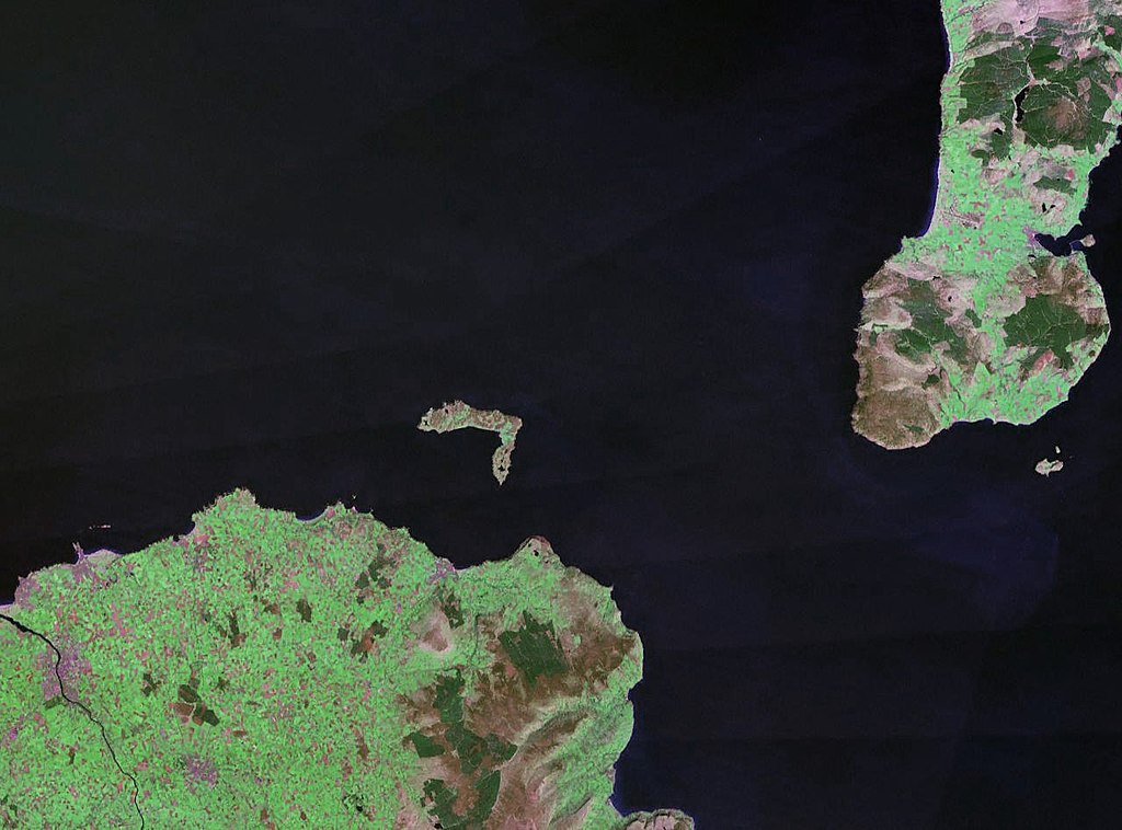
| 描述 | Rathlin Island in Northern Ireland. The coast of County Antrim is to the south, and the tip of the Kintyre Peninsula is to the east. |
| 日期 | 约1990年 |
| 来源 |
NASA World Wind (landsat geocover 1990 data) Original image obtained fron NASA World Wind, colour and saturation tweaked with Adobe Photoshop. |
| 作者 | NASA |
| 授权 (二次使用本文件) |
USgov-PD |
| 本图像属于 w:公有领域 ,因其为 NASA 的 World Wind 卫星地图浏览器的一张截图,且使用了公有领域图层,如 Blue Marble、MODIS、Landsat、SRTM、USGS、GLOBE 等。
|
 |
文件历史
点击某个日期/时间查看对应时刻的文件。
| 日期/时间 | 缩略图 | 大小 | 用户 | 备注 | |
|---|---|---|---|---|---|
| 当前 | 2006年4月24日 (一) 22:30 | | 1,280 × 948(216 KB) | Finlay McWalter | {{Information| |Description=Rathlin Island |Source=NASA World Wind (landsat geocover 1990 data) |Date=c. 1990 |Author=NASA |Permission={{PD-WorldWind}} |other_versions= }} |
文件用途
以下页面使用本文件:
全域文件用途
以下其他wiki使用此文件:
- af.wikipedia.org上的用途
- br.wikipedia.org上的用途
- ca.wikipedia.org上的用途
- ceb.wikipedia.org上的用途
- cs.wikipedia.org上的用途
- da.wikipedia.org上的用途
- de.wikipedia.org上的用途
- en.wikipedia.org上的用途
- eo.wikipedia.org上的用途
- es.wikipedia.org上的用途
- et.wikipedia.org上的用途
- eu.wikipedia.org上的用途
- fr.wikipedia.org上的用途
- ga.wikipedia.org上的用途
- gv.wikipedia.org上的用途
- hu.wikipedia.org上的用途
- ja.wikipedia.org上的用途
- kk.wikipedia.org上的用途
- lt.wikipedia.org上的用途
- nn.wikipedia.org上的用途
- no.wikipedia.org上的用途
- pl.wikipedia.org上的用途
- pt.wikipedia.org上的用途
- ru.wikipedia.org上的用途
- sv.wikipedia.org上的用途
- www.wikidata.org上的用途